Keeping The Seas Safe
One of the pleasures of being based at the University of Greenwich, at the centre of the world, in terms of longitude, and at the centre of world time, is commuting on the fast catamaran from Embankment in central London eastwards towards Greenwich – and home again. Further east, beyond that historic centre of maritime endeavour and science lie the Thames Barrier, the new London Gateway port, the Thames Estuary and the North Sea. During February 2014 the United Kingdom was struck by heavy flooding, which for some of the time coincided with a storm surge, when low pressure sucks up the sea, and makes high tides even higher. The Thames is tidal all the way up to Teddington Lock, in south-west London. But the main focus of media attention was flooding, a result of a month’s near-continuous rain and the ensuing high ground water levels, particularly west of London. One morning when the floods were at their height, this author heard one of the clipper’s crew telling another commuter that the Thames Barrier was raised, into the defensive position. ‘Why? Surely they want to let the water out?’, I asked.
The complexities of managing water, environmental change and damage, became clear. When the tide is coming in, with considerable force, it pushes back the flood waters, which are trying to flow downstream to the sea. So, when the tide is coming in, the Barrier is raised, to stop that process. That gives the inland flood waters more opportunity to flow into the basin created. Then, when the tide turns, the Barrier is opened, and the head of water can flow out. Simple, but ingenious. That, it must be said, is not what the Thames Barrier was designed for. It was designed to defend London against water coming in from the east, especially storm surges. But, it transpires, it can also stop the tide holding ground water back.
During those wet days, we suffered from excess ground water, storm surge and high winds. We might just muse on what would have happened had all that coincided with – a full moon.
It is unclear how far climate change was responsible, if at all, for the unusual weather conditions experienced in February. A change in the course of the jet stream was widely blamed. But climate change is certainly impacting on all aspects of the marine and littoral environment, including wildlife, human infrastructure, recreation and tourism. The oceans produce half the planet’s supply of oxygen, mainly because of the chlorophyll in aquatic algae. But concentrations of that chlorophyll are falling. That will not necessarily mean that we will suffocate, but it may add to climate change, since less oxygen means more carbon dioxide.
Some of the key problems affecting the oceans do not emanate from the oceans themselves. Two of the biggest problems – acidification and pollution – emanate from the land. Most of the damage done is within states’ 200 nautical mile Exclusive Economic Zones (EEZs). Paradoxically, this is where most fishing takes place, and hence where the damage to immediate human interests is greatest. These issues are therefore ultimately susceptible, in large measure, to the laws and governance of individual states.
The most obvious immediate consequence of climate warming has been the shrinking of the Arctic ice cap. This has been seen as an issue with positive as well as negative consequences: the opening up of the relatively shallow Arctic Ocean as a transport avenue and for extraction of resources. However, it may be another 20 years before the Arctic route, and especially the Northern Sea Route (NSR) north of Russia offers viable commercial alternatives to the traditional routes between the Asia-Pacific rim and Europe via the Malacca Strait, the Suez Canal and the Cape. At present, ‘Arcticmax’ ships – the largest that can transit the route – are much smaller than those which can use the other routes – Ultra Large Container Ships and Very Large Crude Carriers, new Panamax, Suezmax, and Cape Size. That is not only because of choke points in the Northern Route, but also because of Russian dominance. Russian regulations demand that icebreakers are available, and an Arcticmax ship can be no broader in the beam than an icebreaker. In maritime trade, size matters, and even though the NSR could typically shave nine days and 2,800 nautical miles off a voyage from China to Rotterdam, the limitations on the current size of ships using the NSR will mean that the traditional routes will win every time. Furthermore, even with a largely ice-free summer Arctic, the route is still potentially only open for four to five months.
The term ‘high seas’ traditionally referred to the great expanse of sea and ocean outside the territorial seas, established as 12 nautical miles from the coastal baseline by the 1982 UN Convention on the Law of the Sea (UNCLOS). However, the term is now used for the expanse of water beyond the EEZ – 200 nautical miles, or more if states can prove a claim based on the extent of the continental shelf beyond this limit, as far as 350 miles. These shrunken ‘high seas’ still cover half the planet. UNCLOS is the legal framework which governs this global space. The Convention is widely respected and almost every country has ratified it. Even the US, which refuses to sign it, abides by its provisions. But most of UNCLOS was negotiated in the 1970s when environmental issues were barely considered. It therefore does not provide mechanisms to punish those who violate its provisions. Specialised bodies have been set up to oversee some parts of the treaty, including the International Seabed Authority, which regulates mining beyond EEZs. Until now, there has not been much for it to do but technological advances are now opening up the deeper ocean depths to exploitation. This has led to calls for an international authority to simplify and untie the existing knot of overlapping organisations. The German Advisory Council on Global Change has called for an entirely new body, a World Oceans Organisation. A small high-level body has been formed, called the Global Ocean Commission, chaired by former Costa Rican President José Maria Figueres, Minister in the South African Presidency Trevor Manuel, and former UK Foreign Secretary David Miliband. But it is only a think tank: it has no international authority.
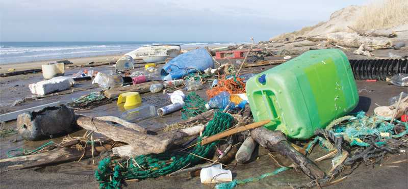
If many of the problems impact within EEZs, and can potentially be solved by the littoral states, there are two big issues which only a World Oceans Organisation can solve. One is over-fishing. Over-fishing is twice as prevalent on the new high seas as in EEZs, where Illegal, Unregulated and Unreported (IUU) fishing is an offence. Over-fishing leads to other damage to the marine environment. The other huge problem arises from issues relating to the presence and disposal of plastics in marine environment. We are all familiar with the damage done by plastic bags in the beach and coastal environment, particularly to marine fauna, but plastics are a major hazard further out to sea. The most prominent example is the Great Pacific Garbage Patch, also known as the Pacific Trash Vortex, which now stretches across much of the north Pacific. It was discovered by Captain Charles Moore on a trans-Pacific voyage in 1993, when he chose to cross the gyre which most seafarers avoid. The Great Pacific Garbage Patch is now concentrated in an area between the US states of Hawaii and California. Plastic debris is concentrated here by the North Pacific Subtropical Gyre, a circular ocean current formed by the earth’s wind patterns and the forces created by the earth’s rotation. Like the ‘eye’ of a storm, the centre of a gyre tends to be very calm and stable, while its circular motion sucks in debris, and then prevents it escaping. Were the rubbish bio-degradable, this would not be such a problem, but most plastic is not. Most plastics do not break down chemically but simply – and here’s the rub – disintegrate into smaller and smaller pieces.
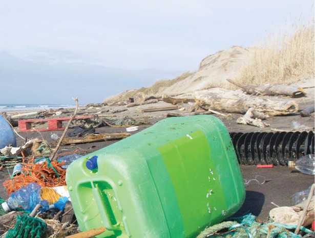
Plastic products can be very harmful to marine life. Loggerhead Sea Turtles, for example, often mistake plastic bags for jellyfish – their favourite food, while marine animals and birds such as albatrosses are strangled by the plastic rings used to hold six-packs together. As plastic and other rubbish concentrates on the surface of the water they block sunlight from reaching algae and plankton below. These are the most common autotrophs in the marine food chain – organisms that can produce their own nutrients from oxygen, carbon and sunlight. The effect will snowball. Fish, cetaceans and turtles that feed on algae and plankton will have less food, and if they die off, there will be less food for predators like tuna, sharks and carnivorous whales.
But the effect of plastic disintegrating into smaller and smaller pieces is perhaps the most terrifying of all. At a Global Ocean Commission seminar in Oxford on 21 November 2013, Professor Alex Rogers of Oxford’s Zoology Department described an expedition to the Pacific. He said that from several metres down to more than a kilometre the water was absolutely permeated with small shreds of plastic. The effect on marine creatures which swallowed them, and on the bigger creatures that swallowed them, and, ultimately, on us, is difficult to predict, but could be catastrophic.
As population growth and globalisation allow us to penetrate and exploit the deeper seas, and as technology allows us to, it is surely time to reappraise the governance of the half of the world that is still ‘high seas’, and the global commons that the vast if finite resources within them represent.
Professor Chris Bellamy
Director Greenwich Maritime Institute,
University of Greenwich

